Definition: jaunt -
noun a short journey taken for pleasure;
verb to go on a jaunt
Synonyms: adventure, amble, circuit, constitutional, course, excursion, frolic, hike, junket, outing, peregrination, prowl, ramble, ride, sally, saunter, trip
I always like to have a destination for a ride. These are some that involve a particularly pleasant journey, that seem a bit out of the ordinary, or might be interesting to others. The decision of the judges on what to include is final, but I'm open to challenges, and welcome new suggestions.
Where I have posted separately on destinations they are listed
here.
The
Shepperton / Weybridge ferry is a pedestrian (and cycle) ferry that crosses the Thames between Ferry Lane in Shepperton and a point near Thames Street in Weybridge. There has been a ferry here for over 500 years. In H. G. Wells' War of the Worlds there is a battle with the Martians here as crowds wait to cross the river. The ferry operates from 8am on weekdays (9am on Saturdays, 10am on Sundays) until 5pm. It pays to get there on time, because the nearest alternative crossing involves a round trip of about 3 miles. The ferry is on National Cycle Route 4. [
Map]
Turville is the location where they filmed the Vicar of Dibley, as well as Went the Day Well?, Goodnight Mister Tom, Chitty Chitty Bang Bang and episodes of Midsomer Murders, Lewis, Jonathan Creek and Day of the Triffids. The village is overlooked by the Cobstone Windmill. Turville is one of a number of attractive villages in the area, linked by a lovely local cycle route that starts and ends in Marlow. The more energetic can continue up the hill to Christmas Common. [
Map]
General Roy's cannon marks the end of a baseline that was used by William Roy to triangulate and map south east England in 1784. Roy's work led to the foundation of the Ordnance Survey in 1791. By then the wooden posts that originally marked the ends of the baseline were already decaying and they were replaced by guns buried vertically. It stands next to the Heathrow perimeter road, which isn't the best place to cycle, but it is close to National Cycle Route 61. [
Map]
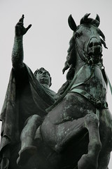
Mad King George III was King of Great Britain and Ireland from 1760 until his death in 1820. In the later part of his life he suffered from recurrent and eventually permanent mental illness, now thought to be porphyria. On Snow Hill in Windsor Great Park there is a huge equestrian statue of him, at the end of the Long Walk. It was commissioned by his son, George IV. The two did not get on, and the plinth bears the ironic inscription PATRI OPTIMO (the best of fathers). Both National Cycle Route 4 and the Round Berkshire Cycle Route pass through Windsor Great Park - which itself is well provided with cyclable paths.[
Map]
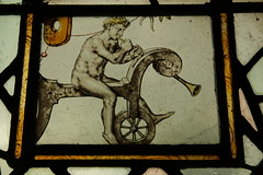
The bicycle window in St Giles church, Stoke Poges dates from 1643. It appears to show a naked cyclist on a "hobby horse" blowing a trumpet. Thomas Gray's Elegy Written in a Country Churchyard is supposed to have been created in the churchyard, where Gray is buried. Nearby there is a grotesquely large monument to the poet. Local roads are a bit busy, and Stoke Poges is on the wrong side of Slough for National Cycle Route 4. However, National Cycle Route 61 is about 5 miles east, and Burnham Beeches is about 5 miles west. [
Map]
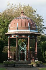
The Maharajah's Well in Stoke Row was financed by the Maharajah of Benares in 1864. He was told that a local boy had been beaten by his mother, because he drank all the water she had during a drought, and she faced a long trip to collect more. The Maharajah was so touched that he provided the village of Stoke Row with a well, an ornate canopy , a golden elephant and a keeper's cottage. The well was renovated in the 1950s and still works. It is on National Cycle Route 5, and the Chilterns Cycle Way. [
Map]
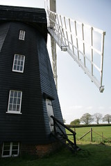
Lacey Green windmill is the oldest surviving smock mill in England and was restored from almost total collapse by volunteers. The machinery dates from around 1650, though the body of the mill was rebuilt in the early 19th century. The mill isn't far from National Cycle Route 57. The nature of the ride depends on which direction you approach the village. Going south it is a bit of a climb up from Princes Risborough, but the road back into high Wycombe, past the RAF station, is a long downhill glide. [
Map]
There are several locks along the Thames which are a worthwhile destination. I regularly visit Boulter's Lock [
Map] in Maidenhead, because that is nearest to home. It's lies on Sustrans Regional Route 52 / the Round Berkshire Cycle Route. There's usually plenty of activity. In the summer there's a stall that sells ice cream, and there's a popular café just down the road that does good bacon sandwiches (I'm told). But for me Boulter's lock is too close to home to be a proper destination so I pick Hurley [
Map] for a slightly longer ride. Hurley also lies just off Sustrans RCR52 and the Round Berkshire cycle route. It's on the Thames path, which provides a decent loop via Marlow (if you take care, and don't mind riding off roads). You can get a drink and slice of cake at the lock, and it's worth having a peek at the traditional Thames boats in the Peter Freebody boatyard. Leave your chequebook at home.
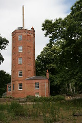
Chatley Heath Semaphore Tower is one of a line of semaphore towers that were used to send messages from the Admiralty in London to the navy in Portsmouth (a distance of about 70 miles). It was used from 1822-1848, and restored by Surrey County Council in 1989. They have displays and models to show how it all worked. As you would expect there are good views from the top of the tower. Motorists park just off the A3, and walk across the heath to the tower, but the easiest access on a bike is from local cycle route E2, which runs down Pointers road on the other side of the M25. Coming from Weybridge there is a nifty set of toucan crossings and bridle paths which negotiate the M25/A3 junction. Visits need to be planned, as the tower is only normally open on the first Sunday of the month through the summer. [
Map]
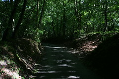
Holloway Lane runs from Northend to Turville. It runs the other way as well, of course, but that's quite a tough climb. My preference for the climb is to take one of the more manageable routes to Christmas Common, then turn through Northend, and enjoy the long descent down the lane. The Chilterns Cycle Way runs through Christmas Common - so it provides a couple of options: from the south-west via Cookley Green or from the north-east via Stokenchurch. I don't know anything about the history of the lane itself, but it looks ancient, with steep banks on both sides, and a canopy of trees overhead. At the bottom, the road passes through Turville, and links to a local cycle route. From there I normally carry on to Hambleden, where they serve tea in the churchyard on summer sunday afternoons. [
Map]